Smart Infrastructure Products · PRD-07
Geo-Fencing Solution
Location-Based Operational Intelligence
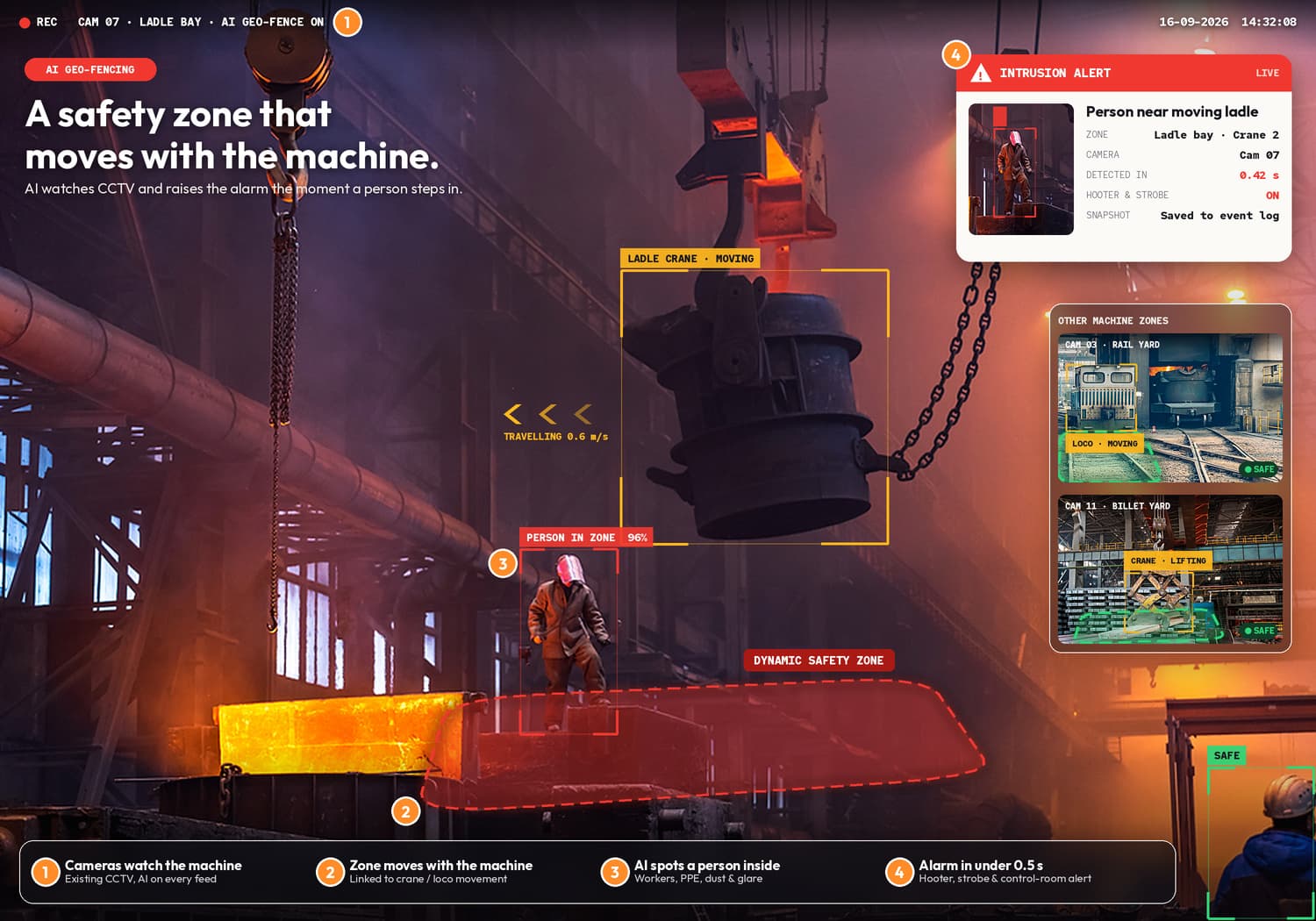
The Geo-Fencing Solution is designed to help organisations define virtual boundaries and generate automated alerts and intelligence based on location and movement.
- GPS Location Data
- Virtual Boundaries
- Vehicle Tracking Integration
- Automated Alerts
- Dashboard Monitoring
The Problem
Assets keep moving. Boundaries need constant watching.
Industrial plants, mining operations, logistics and infrastructure sites have restricted areas, routes and zones where the movement of vehicles and assets matters. Tracking what enters or leaves those areas by manual observation is difficult across large sites, and events can be noticed late.
The NIVOSK Solution
Virtual boundaries with automated alerts.
The Geo-Fencing Solution lets teams define virtual boundaries around sites, zones and restricted areas, monitors location and movement through vehicle tracking integration, and generates entry and exit alerts, operational event alerts and dashboard intelligence.
- GPS Location Data
- Virtual Boundaries
- Vehicle Tracking Integration
- Automated Alerts
- Dashboard Monitoring
Key features
Key Capabilities
- 01
Virtual Boundary Creation
- 02
Entry and Exit Alerts
- 03
Location Monitoring
- 04
Asset Movement Intelligence
- 05
Vehicle Tracking Integration
- 06
Operational Event Alerts
- 07
Dashboard Monitoring
Technology stack
What Powers Geo-Fencing Solution
- Sense
- GPS · Vehicle Tracking
- Understand
- Virtual Boundaries · Location Monitoring
- Process
- Entry / Exit Detection · Asset Movement Intelligence
- Decide
- Automated Alerts · Dashboard Monitoring
- Connect
- Vehicle Tracking Integration · Cloud · Enterprise Systems
Use cases
Real-World Applications
Restricted Area Monitoring
Plant Vehicle Movement Monitoring
Mine Site Vehicle Boundaries
Logistics Fleet Zone Alerts
Asset Movement Tracking
Infrastructure Site Perimeter Alerts
Industries
Where Geo-Fencing Solution Applies
- Industrial Plants
- Mining Operations
- Logistics
- Restricted Areas
- Vehicle Operations
- Infrastructure Sites
Benefits
Business and Operational Outcomes
- 01
Improved Safety
Automated alerts when vehicles or assets enter or leave restricted areas.
- 02
Better Visibility
Location and movement of tracked vehicles and assets on one dashboard.
- 03
Asset Monitoring
Understand where tracked assets are and how they move across the site.
- 04
Faster Decision-Making
Entry, exit and operational event alerts are generated as events happen.
- 05
Operational Efficiency
Reduce manual boundary checks across large or dispersed sites.
Integration
Connects With What You Already Run
Every NIVOSK product is designed to connect with cameras, sensors, GPS, PLC, SCADA, cloud and existing enterprise systems. Highlighted nodes are the primary integrations for Geo-Fencing Solution.
- CAM
Cameras
Industrial and AI cameras
- SNS
Sensors
IIoT and machine sensors
- GPS
GPS (primary integration)
Location and movement
- PLC
PLC
Control-level integration
- SCD
SCADA
Monitoring and visualisation
- CLD
Cloud (primary integration)
Remote monitoring and storage
- ERP
Enterprise Systems (primary integration)
Existing business systems
FAQ
Questions About Geo-Fencing Solution
What it is, where it applies, how it works and how it connects with the systems you already run.
What is the Geo-Fencing Solution?
The Geo-Fencing Solution is designed to help organisations define virtual boundaries and generate automated alerts and intelligence based on location and movement. It combines GPS location data, virtual boundaries, vehicle tracking integration, automated alerts and dashboard monitoring.
Which applications is the Geo-Fencing Solution designed for?
Industrial plants, mining operations, logistics, restricted areas, vehicle operations and infrastructure sites.
How does geo-fencing work?
Virtual boundaries are defined around sites, zones or restricted areas. Location data from tracked vehicles and assets is monitored against those boundaries, and entry, exit and operational event alerts are generated automatically.
What can the Geo-Fencing Solution monitor?
The location and movement of vehicles and assets relative to defined boundaries — including entries and exits, asset movement and operational events — with results shown on dashboards.
How does the Geo-Fencing Solution integrate with existing systems?
Through vehicle tracking integration using GPS location data, with alerts and dashboards that can connect to cloud platforms and existing enterprise systems.
How do we get started?
Request a demo, or discuss your requirement with us. We start by understanding the site, the process, the existing systems and the outcome you need.
See it running
Request a Demo
A walkthrough of Geo-Fencing Solution on representative footage from your environment.
Request a Demo →Start with the problem
Discuss Your Requirement
Tell us about the site, the process, the existing systems and the outcome you need.
Discuss Your Requirement